Interactive Image of St. George's Caye
 Beachfront Property For Sale on St. George's Caye, Belize
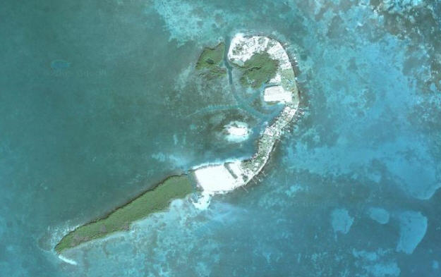
The above photo is a satellite image of Saint George's Caye which was provided by Google Earth. Anyone familiar with Google Earth will immediately know how to manipulate this image so that they can see closeups of the island, visit Belize City or the reef, and even see where the island is situated relative to Houston or Paris. Google Earth really is a trememdously powerful tool.
For those of you who are not familiar with Google Earth the following suggestions are intended to assist you in getting started;
- First click on the above image itself and that will enhance the size of the shot.
- Then, to see closeup images of any particluar portion of the image that appears on your screen,
simply double click on the spot which you wish too see more closely. (Clicking on the "+" will do
the same thing.)
- To talk a "walking tour" of the island, simply left click with your mouse and, while holding
that click down, "drag" the island around by moving the mouse itself. By doing this you can see
how many houses you would encounter between the property that is for sale and either end of the island.
(I counted 18 going south from the property...)
- There is also a tool that appears at the top left hand side of the screen which permits you
to move further away as well as to come much closer to the area you are interested in.
By clicking on the "+" and "-" signs you will be able to see views which include just the lots
themselves as well as the entire world. Starting with this image you should be able to see what
your cousin's house looks like from a satellite. It really is lots of fun,
as well as being a very useful tool.

Copyright © 2008-2016 by Belize Beachfront Property. All rights reserved.
Home
Undercurrent Article
June 3, 2009
Why Belize?
Beachfront Land for Sale
Alternative Uses
Government Approved Subdivision
Photo Page
Interactive Image of
St. George's Caye
Map of Belize Cayes
Current Weather

Contact Us